
University of Cambridge: Geophysical Investigation
Rochester Building and Damp were brought in to advise during refurbishment works at the Old Addenbrooke’s site. Early on, contractors noticed movement in a brick arch above a window. That movement led to a cracked cast-iron pipe, which began leaking into the structure.
Once the stonework, brickwork and pipe were repaired, the immediate damp problem eased. The building looked stable again. Then a different issue showed itself at ground level. Moisture was still pushing through the flank wall of the library and it wasn’t improving.
The contractors asked Rochester Building and Damp to step in, identify what was driving the ingress and suggest a practical way forward.The setting made things more delicate than usual. The Victorian library sits beside buried remains of a 14th-century chapel. Any digging or intrusive investigation was off the table from the outset.
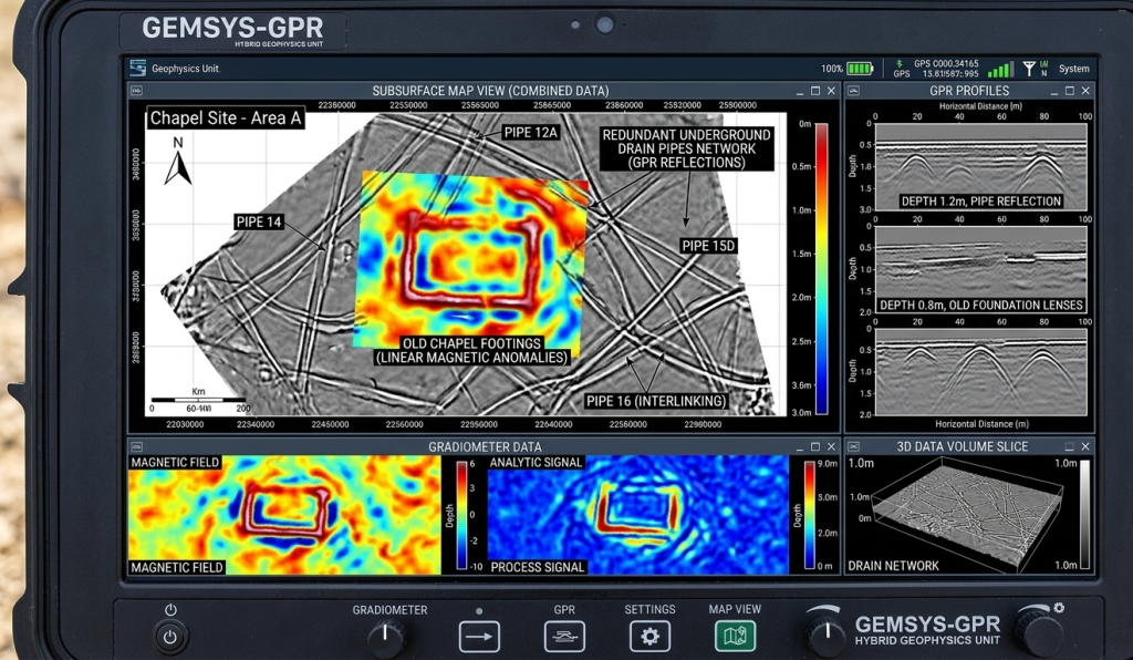
A geophysical survey became the only sensible route. Working along the flank wall, Rochester Building and Damp mapped what lay beneath the surface. The picture that formed was more complex than expected. The original chapel footings were still present and alongside them ran a web of old drainage lines, many long out of use but still physically intact underground.
The first pass used a gradiometer to pick up variations in subsurface structure. On the second day, ground penetrating radar gave a clearer view of depth and layout.
By the third day, something unexpected appeared. A hidden manhole, tucked behind trees and dense foliage, roughly 30 metres from the library wall.
Archive records helped make sense of it. The chamber dated back to drainage works carried out in the 1940s, when the system across the site was completely rerouted.
Over time, a partial blockage developed within that network. Water began backing up into the manhole intermittently, then escaping through a redundant pipe positioned just beneath the Yorkstone cover slab. That pipe led nowhere useful. It simply terminated in the ground, around two metres from the library wall, at a depth of between 1.5 and 2 metres.
That detail changed everything.
Water was collecting below ground in close proximity to the building, saturating the surrounding soil and driving moisture directly into the flank wall. The rate of ingress matched what was being seen internally. Once the pathway was understood, the cause was no longer in doubt.
The findings were passed to the contractors, who returned to site and dealt with the drainage failure at source. After the system was corrected and the excess water removed, the ingress stopped.
A handwritten letter later arrived from Regent House, expressing genuine appreciation for the clarity of the investigation and the outcome achieved.
The survey work itself required careful planning.
Initial ground assessment showed roughly 500mm of topsoil over a dense clay layer of similar depth. Beneath that sat a substantial chalk formation, which influenced how the radar behaved.
To deal with this, a refractor system was introduced. It split the radar signal into three controlled electromagnetic pulses and guided them along the chalk interface. That allowed a wider and deeper sweep without signal degradation.
A second GPR receiver was positioned 8 metres from the transmitter, running in parallel. Keeping a fixed separation between the units improved consistency across the dataset and made it possible to cover a large area efficiently without losing resolution.
What emerged from that combination of survey techniques was not just a map of buried structures, but a clear explanation for a persistent and costly damp problem.


“Many thanks for your assistance in this most troublesome of matters. Damp would appear to be an affliction which requires a particularly high level of expertise. In my opinion, Rochester Building and Damp provide an exceptional service……”
D.W.Allen ScD. Regent House.